
- About us
- Company details
LOKI S.r.l. is an innovative startup with a clear mission: improve road safety through technology. By integrating artificial intelligence, high resolution cameras, advanced satellite navigation systems, and high-precision sensors, the company provides cutting-edge solutions for road monitoring and predictive maintenance.
Poor road conditions lead to high maintenance costs for public administrations, vehicle damage, and increased safety risks for drivers, cyclists, and pedestrians. Traditional inspection methods, based on manual visual checks, are slow, expensive, and often ineffective, making it difficult to repair road defects in time. The lack of accurate and up-to-date data on infrastructure conditions prevents efficient planning, causing further deterioration and higher long-term repair costs.
LOKI addresses these challenges with a technological approach that automates road monitoring, reducing both inspection time and maintenance expenses. The company’s plug-and-play system can be installed on any vehicle, collecting real-time data while in motion. Artificial intelligence analyzes images and sensor readings to detect potholes, cracks, and other road defects with high accuracy. Advanced GNSS technology, including Galileo HAS and OSNMA, ensures precise geolocation of defects, providing certified and reliable data for legal and insurance purposes.
The LOKI team brings together experts in engineering, AI, GNSS, and software development, with experience in aerospace, automotive, and ICT industries. This diverse expertise allows the company to develop advanced, scalable solutions that integrate seamlessly into existing infrastructure management processes. LOKI has already gained recognition at the European level, securing incubation at ESA BIC Turin and winning the EIT RAPTOR program, validating the impact of its innovation.
Beyond AI and GNSS, LOKI leverages Earth observation data from the Copernicus program to monitor ground motion and anticipate structural risks that could compromise road stability. Cloud-based processing enables scalable data analysis, providing administrations with intuitive tools for infrastructure planning and decision-making.
With this approach, LOKI enhances road safety and supports the development of more efficient and resilient cities. The company enables a shift from reactive infrastructure management to a predictive strategy, optimizing maintenance budgets and reducing resource waste. LOKI aims to become a key player in road infrastructure monitoring, delivering smart solutions that make roads safer, more efficient, and accessible for all.
Year of establishment:
2023
Number of employees:
FROM 3 TO 9 EMPLOYEES
Annual turnover:
Under 250.000 Euro
Reference year of turnover:
2024
Export turnover:
Less than 75.000 Euro
Activities:
Other information technology and computer service activities nec
Other data processing
- Videos
- Catalogue
Imagine a city where road and pedestrian infrastructure is monitored automatically, efficiently, and in real-time. With Asfalto Sicuro® and AIPECRA, this future is now a reality.
 LOKI's pitch presentation
- Contact Information
- Business Proposals
Company:
LOKI S.R.L.
Web site:
Address:
VIA BERTOLA 12
City:
SAN SEBASTIANO DA PO (TO)
Zip Code:
10020
E-commerce:
Social media:
Tag:
No business proposals uploaded
- Map
Asfalto Sicuro®
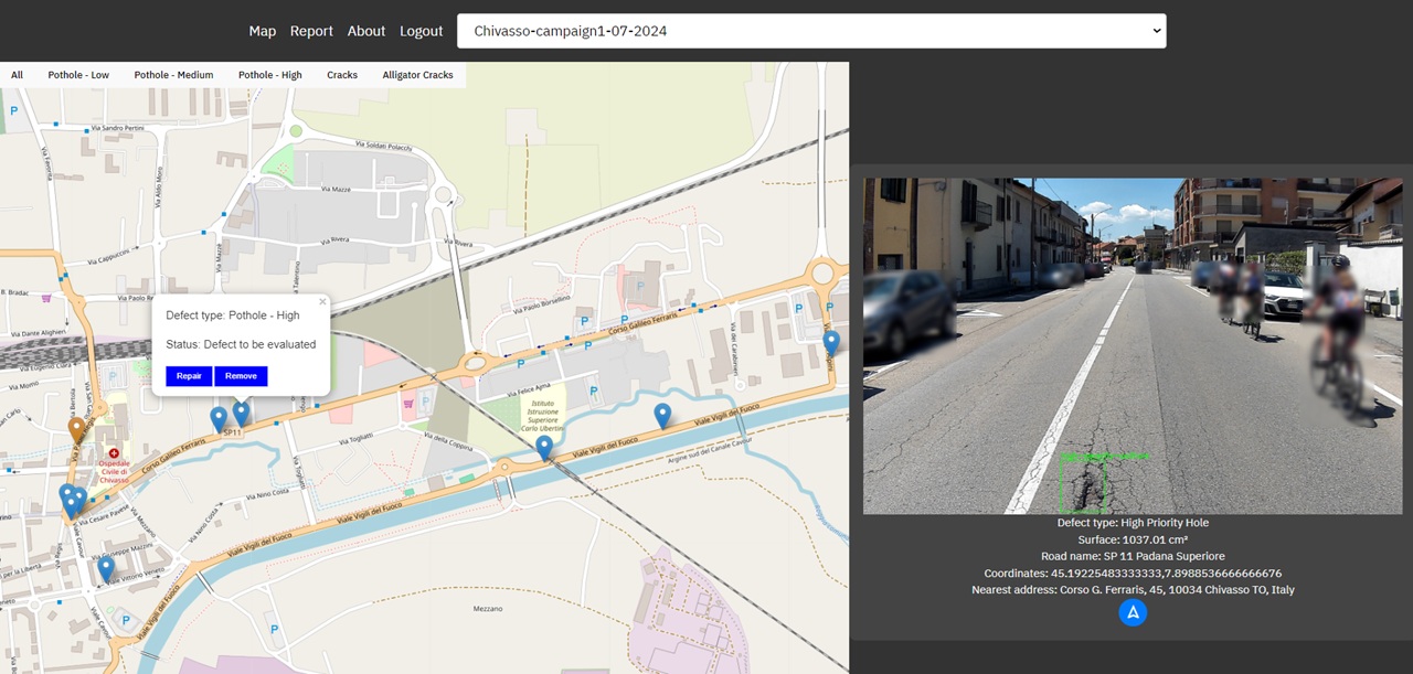
Asfalto Sicuro® is an advanced solution that transforms road monitoring and maintenance through artificial intelligence, high-resolution imaging, and satellite navigation technologies. Designed to optimize road infrastructure management, it provides municipalities, road authorities, and maintenance companies with a fast, accurate, and cost-effective tool to detect, geolocate, and classify road defects.
How It Works
Asfalto Sicuro® integrates AI-powered image analysis, GNSS-based precise geolocation, and inertial measurement sensors (IMU) to identify potholes, cracks, and surface irregularities. The system is installed on any vehicle, collecting data in real time while moving at normal speeds. Unlike traditional visual inspections, which are slow, expensive, and inconsistent, this approach ensures continuous and automated infrastructure assessment without disrupting traffic.
Data Collection:
Vehicles equipped with high-resolution cameras capture road surface images.
IMU sensors detect variations in road texture and stability.
GNSS receivers (Galileo HAS & OSNMA) ensure precise positioning and authenticated geolocation of defects.
AI-Powered Analysis:
AI algorithms process images and sensor data to detect and classify road defects based on severity.
The system automatically filters sensitive data, ensuring compliance with privacy regulations (GDPR).
A structured database of defects is created, including type, severity, and geolocation.
Actionable Insights & Reporting:
The collected data is visualized on an intuitive dashboard for easy decision-making.
Reports can be exported for integration into GIS systems and smart city platforms.
Maintenance teams receive prioritized intervention plans, optimizing resource allocation and reducing response time.
Key Benefits
Faster Inspections: Reduces inspection times by up to 60% compared to manual methods.
Cost Reduction: Lowers maintenance costs by up to 70% through targeted interventions.
Enhanced Road Safety: Helps prevent accidents and minimizes damage claims, reducing insurance-related costs by up to 80%.
Scalability & Flexibility: Can be deployed on public transport fleets, waste collection trucks, or dedicated vehicles, allowing continuous monitoring of urban and highway networks.
Predictive Maintenance: Future versions will integrate satellite-based ground motion analysis (Copernicus) and weather data to anticipate road degradation before visible defects appear.
Why Asfalto Sicuro®?
Traditional road inspections rely on manual surveys or expensive LiDAR systems, both of which have significant limitations. Asfalto Sicuro® offers a cost-effective, AI-powered alternative that enhances precision, reduces operational complexity, and increases monitoring coverage. The use of authenticated GNSS positioning ensures legal-grade accuracy, making the data suitable for infrastructure liability assessments and insurance validations.
By enabling data-driven road maintenance, Asfalto Sicuro® supports smart city initiatives, reduces environmental impact by optimizing repair schedules, and enhances mobility conditions for all road users, including cyclists and pedestrians. The system is already in use by municipalities and road authorities in Italy and Spain, proving its effectiveness in real-world applications.
With its unique combination of AI, high-resolution imaging, and satellite technology, Asfalto Sicuro® is setting a new standard for road monitoring, ensuring safer, more efficient, and more sustainable infrastructure management.
Documents
AIPECRA - AI PEdestrian CRosswalks Accessibility
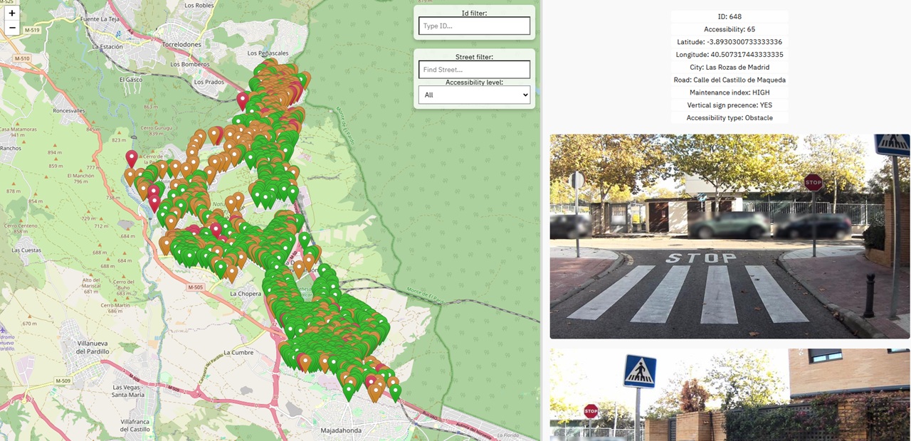
AIPECRA (AI Pedestrian Crossing Accessibility) is an advanced solution designed to assess and improve pedestrian infrastructure by automating the detection and classification of crosswalks and accessibility barriers. Using artificial intelligence, high-resolution imaging, and GNSS-based geolocation, AIPECRA provides municipalities and urban planners with accurate, real-time data on pedestrian crossings, ensuring safer and more inclusive mobility for all users, including people with reduced mobility.
How It Works
AIPECRA is installed on any vehicle, allowing for continuous monitoring of pedestrian infrastructure during normal urban mobility. The system combines multiple technologies to identify and evaluate the quality, safety, and accessibility of crosswalks:
Data Collection:
High-resolution cameras capture images of pedestrian crossings, ramps, sidewalks, and surrounding elements.
IMU sensors detect surface irregularities and evaluate road conditions near crossings.
GNSS (Galileo HAS & OSNMA) ensures precise geolocation of every detected crosswalk and accessibility feature.
AI-Driven Analysis:
AI algorithms identify crosswalk markings, curb ramps, tactile paving, and obstacles such as parked vehicles or street furniture.
The system classifies pedestrian crossings based on safety and accessibility standards, assigning an accessibility score.
Privacy-preserving technology automatically filters out sensitive information, ensuring full GDPR compliance.
Actionable Insights & Reporting:
Data is visualized on an intuitive dashboard, enabling urban planners to identify critical accessibility issues.
Reports provide detailed classifications, indicating areas requiring improvement to comply with mobility regulations.
The system seamlessly integrates with GIS platforms and smart city databases to support long-term planning and targeted interventions.
Key Benefits
Automated and Scalable: AIPECRA covers entire city areas in significantly less time than manual surveys.
High-Precision Geolocation: Uses certified GNSS positioning to ensure legally valid data for accessibility planning.
Improved Urban Safety: Identifies missing ramps, faded crosswalks, and hazardous pedestrian areas to reduce accident risks.
Enhanced Mobility for Vulnerable Users: Provides valuable insights for designing barrier-free pedestrian infrastructure.
Smart City Integration: AIPECRA connects with municipal databases, supporting evidence-based policymaking.
Why AIPECRA?
Traditional pedestrian accessibility audits rely on manual inspections, which are costly, time-consuming, and often incomplete. AIPECRA provides a faster, more precise, and data-driven alternative, enabling cities to prioritize accessibility improvements efficiently.
The system was successfully tested in Las Rozas de Madrid (Spain) under the EIT RAPTOR program, demonstrating its ability to map pedestrian crossings and identify accessibility challenges in just 22 hours.
AIPECRA plays a crucial role in creating more inclusive and walkable cities, ensuring compliance with accessibility regulations and improving pedestrian mobility for all citizens.
Documents