
- About us
- Company details
IAS – Italdron Air Service Srl is an Italian company specialized in Capturing Reality, advanced digital surveying and Digital Twin systems for infrastructures, buildings, industrial assets and complex environments. Founded in 2018, the company operates nationally and internationally, supporting public and private clients in the acquisition, management and transformation of spatial and technical data into structured digital ecosystems.
IAS develops integrated workflows combining precision topography, laser scanning, geomatics, photogrammetry, 3D modeling, BIM-oriented processes and advanced data management, generating high-accuracy digital representations designed for inspection, monitoring, maintenance and asset intelligence applications. The company’s approach is focused on transforming physical reality into reliable and queryable digital assets, supporting technical analysis and long-term infrastructure management.
The company operates across sectors including transport infrastructures, industrial plants, historical heritage, urban environments and complex operational sites, delivering services ranging from high-precision surveys and digital documentation to Digital Twin platforms and immersive technical visualization systems.
Innovation is supported by a multidisciplinary team composed of survey specialists, geomatics experts, data processing technicians and certified operators, working through structured and quality-oriented procedures compliant with national and international standards.
IAS places strong emphasis on reliability, compliance and operational excellence through:
* ISO 9001 certified Quality Management System;
* SOA Certification OS20-A Class II for topographic surveying activities;
* Full regulatory compliance and operational traceability;
* Registration in the Prefecture White List for legality and transparency requirements.
Advanced aerial systems and remote sensing technologies are part of IAS operational capabilities, integrated within broader multidisciplinary methodologies focused on precision data acquisition and digital transformation processes.
Through continuous investment in research, innovation and advanced technologies, IAS positions itself as a reliable technical partner for complex projects involving Capturing Reality, Digital Twins, infrastructure digitization and data-driven asset management.
Year of establishment:
2018
Number of employees:
FROM 3 TO 9 EMPLOYEES
Annual turnover:
between 0.5 and 2.5 million Euro
Reference year of turnover:
2025
Export turnover:
Not available
Activities:
Cartographic and aerophotogrammetric activities
Specialised photographic activities
Activities of photojournalists
Aerial and underwater photography
Other specialised photographic activities
- Videos
- Catalogue
St. PETER'S BASILICA - The video presents a photogrammetric survey of St. Peter’s Basilica in the Vatican carried out with drones, laserscanners, total station, GPS, georadar all in one final project. It showcases the data acquisition process through aerial imagery and detailed architectural captures, aimed at generating a highly accurate 3D model of the monument. The resulting digital reconstruction supports documentation, analysis, and preservation of the cultural heritage.
IPER Market – One of the company’s earliest Scan-to-BIM projects, completed as early as 2017, integrating photogrammetry, static laser scanning, and SLAM technologies. The project represents a comprehensive Digital Twin developed to support asset management and enable efficient monitoring of energy consumption.
A Cinematic Journey into LUXURY HOSPITALITY - The video presents a high-end hospitality experience through cinematic and immersive visual storytelling. It emphasizes refined architectural spaces, elegant interiors, and curated guest experiences, combining smooth camera movements with natural lighting to enhance atmosphere and exclusivity. The narrative focuses on comfort, attention to detail, and premium service, positioning the property as a luxury destination designed for discerning clientele.
Visual Storytelling for BRAND EXCELLENCE - The video showcases a product through a clean, visually engaging promotional narrative, combining dynamic shots and attention to detail. It highlights design, functionality, and key features, using cinematic techniques to enhance perception and value. The result is a compelling visual presentation aimed at strengthening brand identity and capturing customer interest.
A immersive VIRTUAL TOUR Experience - The video showcases an immersive virtual tour designed to provide a realistic and interactive exploration of indoor and outdoor spaces. Through seamless navigation and high-quality visual capture, users are guided across environments with a strong sense of spatial continuity. The experience emphasizes accessibility, detail, and user engagement, making it an effective tool for presentation, remote visits, and digital asset enhancement.
 Company Profile short
SERVICES - CAPACITIES - SKILLS
- Contact Information
- Business Proposals
Company:
ITALDRON AIR SERVICE SRL
Web site:
Address:
VIA FABIO FILZI 25
City:
BELLARIA IGEA MARINA BELLARIA-IGEA MARINA (RN)
Zip Code:
47814
E-commerce:
Social media:
Tag:
No business proposals uploaded
- Map
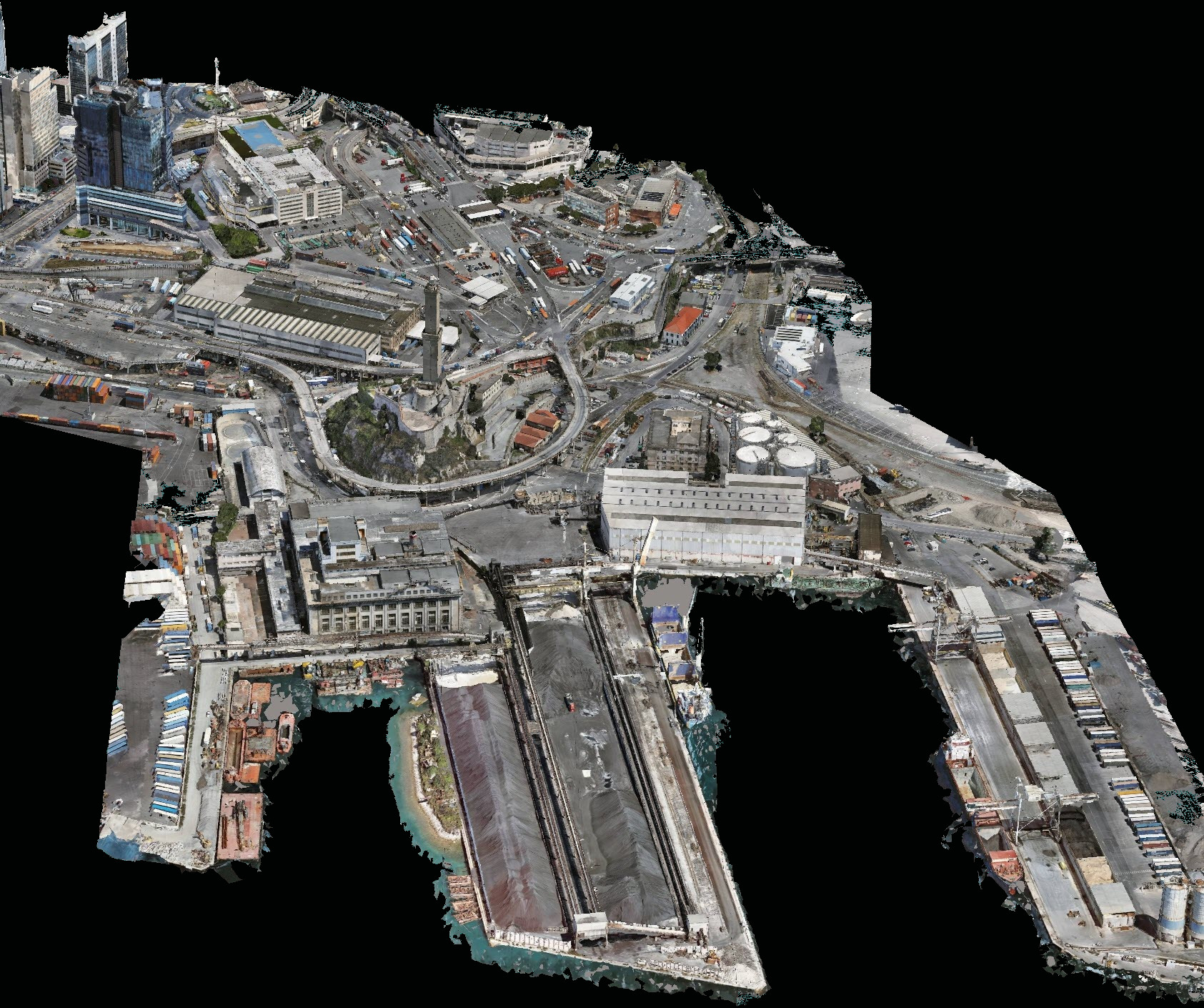
DIGITAL TWIN

FROM PHYSICAL REALITY TO ASSET INTELLIGENCE: IAS Digital Twin is not just a three-dimensional representation, but a georeferenced digital ecosystem built from real data acquired through integrated multisensor surveys.
Intelligent and queryable models: Point clouds, 3D meshes, CAD, BIM, and technical databases are integrated into an advanced digital environment designed for inspection analysis, monitoring, and documentation management.
Asset management and predictive maintenance: The digital model enables the identification of critical issues, comparison of developments over time, association of technical data, and support for decision-making processes focused on proactive maintenance.
Documents
3D MESH PHOTOREALISTIC RECONSTRUCTION
Our textured 3D Mesh is not just a visualization, but a millimetric replica of the existing conditions
Photogrammetric surveys are performed using ultra-high-resolution acquisition for absolute color and geometric precision.
This allows for any technical analysis to be performed, providing essential support for remote visual inspections without additional risks.
It also enables immersive navigation and technical measurements directly on the 3D model, with integration into BIM ecosystems, Digital Twin environments, and Asset Management platforms.
INSPECTIVE IMAGES
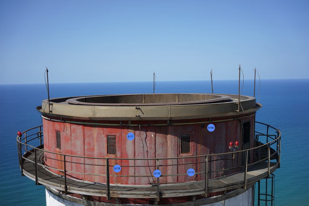
HIGH-DEFINITION VISUAL ACQUISITION FOR TECHNICAL ANALYSIS AND ASSET MANAGEMENT
Secure, high-detail acquisition with ultra-high-resolution RGB, thermal, and multispectral images for close-up analysis of complex infrastructure, systems, and structures, reducing risk exposure and operational disruption.
Georeferenced and contextualized documentation: Each image is integrated into structured digital ecosystems, enabling precise localization, anomaly traceability, and advanced long-term consultation.
Support for advanced inspections and AI: Inspection images provide the information base for crack detection, comparative analysis, periodic monitoring, technical reporting, digital twin platforms, and asset management.
Documents
VIRTUAL TOUR
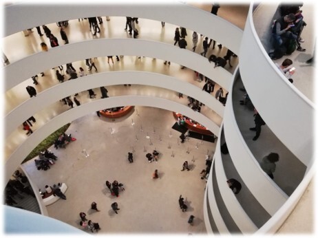
IMMERSIVE NAVIGATION TO EXPLORE SPACES, RESOURCES, AND INFRASTRUCTURE
Create navigable 360° virtual tours of buildings, facilities, infrastructure, historic spaces, and complex environments, accessible remotely via web and mobile devices.
Integrate intelligent data and content. Virtual environments can integrate information hotspots, technical documentation, multimedia content, system tags, inspection reports, BIM connections, and Digital Twins.
VT: an operational and communication tool.
IAS virtual tours support remote inspections, facility management, technical training, real estate development, corporate and museum communications.
EVENT FILMING & CORPORATE VIDEO

AERIAL PRODUCTIONS AND VISUAL CONTENT FOR LIVE EVENTS AND PUBLIC SHOWS
Immersive filming for large-scale events
Video and photography productions with drones, suspended systems, and professional cameras for concerts, sporting events, public performances, and complex live formats.
Operational experience in high-traffic environments
Complete management of operations in regulated environments and in the presence of an audience, through authorization procedures, security management, and dedicated operational coordination.
Dynamic content for broadcast and communication
Creation of cinematic images, recap videos, social media content, and multi-camera productions designed to enhance the atmosphere, reach, and engagement of the event.
VISUAL STORIES FOR COMPANIES, INFRASTRUCTURES, AND REGIONS
High-impact film productions
We create professional video content using drones, cinematic cameras, and advanced filming systems to enhance assets, processes, and corporate identity.
Technical and emotional storytelling
From industrial documentation to institutional content, we combine cinematic language and technical expertise to transform data, spaces, and operational activities into strategic communication tools.
Operations in complex environments
Extensive experience in aerial and ground filming in regulated environments, infrastructure, industrial plants, events, and international productions, with complete management of safety and permits.